

NGA
- North America
- Central, South America
- Western Africa, Mediterranean, Black Sea
- Eastern Africa, Southern Asia
- Australia, New Zealand, Indonesia, Papua New Guinea
- South Pacific Islands
- Eastern Asia, South Eastern Russia, Philippines
- Other Regions
Canadian
Caribbean and Mediterranean
Norwegian
SHOM
SEMAR
U.S.
Search by chart title, key word or chart number:
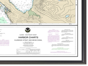
Chart 17423DECOR
Harbor Charts-Clarence Strait and Behm Canal Dewey Anchorage, Etolin Island;Ratz Harbor, Prince of Wales Island;Naha Bay, Revillagigedo Island;Tolstoi and Thorne Bays, Prince of Wales ls.;Union Bay, Cleveland Peninsula

High-Quality Framing
Not For Navigational Use
Actual Chart Size: 30.0" x 24.0"
Prints are crafted on high-quality, resin-coated photo paper with exceptional color range. Custom frames are made of durable anodized aluminum. The beveled face of the frame is 5/16" wide with a depth of 7/16". Framed prints also feature a protective 1/8" non-glare acrylic face.
Frame Style
Black Gloss
Silver Metallic


©2026 Nautical Charts Online, All Rights Reserved.