

NGA
- North America
- Central, South America
- Western Africa, Mediterranean, Black Sea
- Eastern Africa, Southern Asia
- Australia, New Zealand, Indonesia, Papua New Guinea
- South Pacific Islands
- Eastern Asia, South Eastern Russia, Philippines
- Other Regions
Canadian
Caribbean and Mediterranean
Norwegian
SHOM
SEMAR
U.S.
Search by chart title, key word or chart number:
Satellite Charts
Your favorite boating destination can now be beautifully depicted through striking satellite charts.
These charts, created from satellite images, are carefully color-matched to the water of your favorite destination. Upon purchasing, your charts are printed on high-quality photo paper, ready to adorn your walls as you choose or in a frame.
Satellite charts are not intended to meet U.S. or IMO carriage requirements.
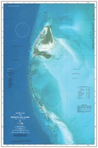 Bimini_Islands
$39.00
The Bimini Islands satellite chart includes north and south Bimini in the Bahamas. The chart extends down to include coverage of Cat Cays and the Great Bahama Bank.
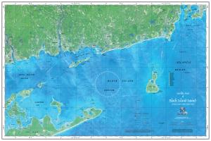 Block_Island_Sound
$39.00
The Block Island satellite chart shows the eastern end of Long Island, Block Island, the Rhode Island coast and Newport.
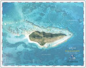 Buck_Island_Reef
$39.00
The Buck Island Reef satellite chart includes the Buck Island Reef National Monument off the coast of St. Croix in the U.S. Virgin Islands, including Buck Island and the surrounding lagoons and coral reefs. This chart also features the Marine Garden lagoon and reefs.
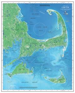 Cape_Cod
$39.00
The Cape Cod satellite chart shows Cape Cod Bay, Nantucket Sound, and Buzzards Bay.
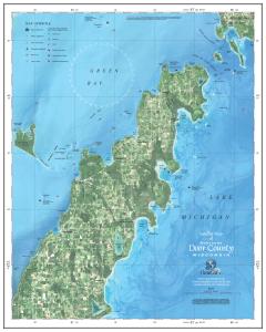 Door_County
$39.00
The Door County satellite chart covers the northern portion of the Door Peninsula in Wisconsin, a prominent Great Lakes destination. The chart also includes the surrounding waters of Lake Michigan, Green Bay, Death's Door Passage, Washington Island and Chambers Island.
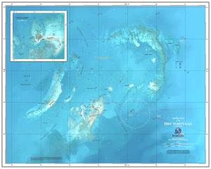 Dry_Tortugas
$39.00
The Dry Tortugas satellite chart depicts the Dry Tortugas National Park in the Gulf of Mexico, which is located 70 miles west of Key West. This chart also shows the Florida Keys chain, including historic Fort Jefferson, and an inset of Tortugas Harbor.
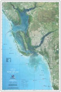 Florida_Gulf_Coast
$39.00
The Florida Gulf Coast satellite chart shows the popular gulf side of the state including the Gulf of Mexico, Sanibel Island, Charlotte Harbor, Fort Myers, and Cape Coral.
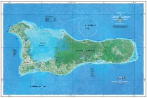 Grand_Cayman
$39.00
The Grand Cayman satellite chart features the island that is the largest and most populous in the Cayman Islands. Surrounded by the Caribbean Sea, it is well-known for Stingray City and one of the Caribbean’s best beaches, Seven Mile Beach.
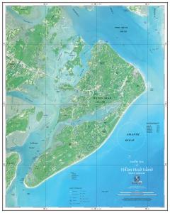 Hilton_Head
$39.00
The Hilton Head satellite chart shows the entire island, with dramatic Broad Creek winding across the mid-section. Included are details from the Port Royal Sound to the north to the Calibogue Sound to the southwest.
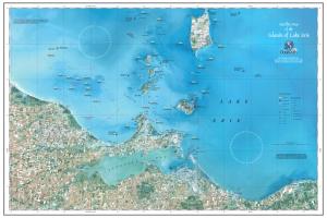 Lake_Erie_Islands
$39.00
The Lake Erie Island satellite chart shows the western basin of Lake Erie centered on the islands, including Put-in-Bay on South Bass Island, plus the shore areas of Sandusky, Port Clinton, Catawba, Marblehead, Huron and Vermilion. This chart also features 30 top fishing reefs!
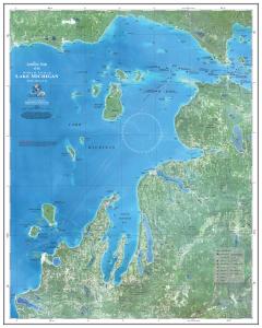 Lake_Michigan_North_End
$39.00
The Lake Michigan North End satellite chart covers the Grand Traverse Bay, Sleeping Bear Dunes, and Manitou Islands areas north to the Upper Peninsula of Michigan, including Charlevoix, Petoskey, Harbor Springs, and the Straits of Mackinac, as well as the islands in Lake Michigan.
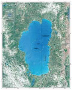 Lake_Tahoe
$39.00
The Lake Tahoe satellite chart covers all of Lake Tahoe along with the surrounding Sierra Nevada and Carson Ranges on both the California and Nevada sides, including seven of the top Lake Tahoe ski areas, mountain peaks, and 15 of the lake's best beaches.
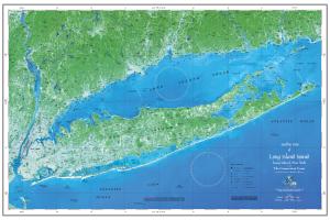 Long_Island_Sound
$39.00
The Long Island satellite chart shows parts of New York, Connecticut, and Long Island.
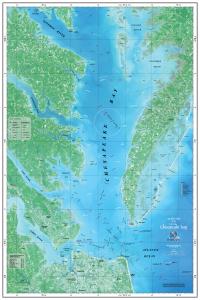 Lower_Chesapeake_Bay
$39.00
The Lower Chesapeake Bay satellite chart covers the lower half of the bay including the Potomac River and Norfolk, following the bay out to the Atlantic Ocean.
 Lower_Florida_Keys
$39.00
The Florida Keys: Lower Keys satellite chart covers one of the most popular year-round vacation destinations. This satellite chart shows the Lower Keys, including Bahia Honda and Key West.
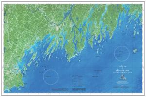 Maine_Coast_Casco
$39.00
The Maine Coast: Casco Bay to Monhegan Island satellite chart covers Portland and Casco Bay east to Boothbay Harbor and Monhegan Island. This chart also includes the Yarmouth, Freeport, Brunswick and Bath areas.
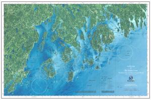 Maine_Coast_Penobscot
$39.00
The Maine Coast: Penobscot Bay to Desert Island satellite chart centers on Penobscot Bay and its hundreds of islands and includes the popular destination of Mount Desert Island, the site of Acadia National Park and Bar Harbor.
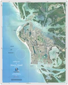 Marco_Island
$39.00
The Marco Island satellite chart is a brilliantly colored and detailed close up of Marco Island, Florida, and its many waterways. You'll also find surrounding passes, backbays, islands and the Gulf of Mexico on this chart.
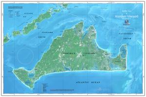 Marthas_Vineyard
$39.00
The Martha's Vineyard satellite chart shows Martha's Vineyard as well as Buzzards Bay, Vineyard Sound, and Nomans Land.
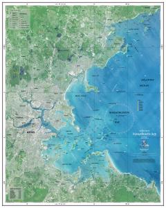 Massachusetts_Bay
$39.00
The Massachusetts Bay satellite chart includes additional coverage of the state of New York as well as Boston Harbor, Marblehead, and Salem Sound.
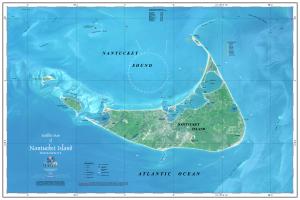 Nantucket
$39.00
The Nantucket satellite chart shows Nantucket and Nantucket Sounds, Massachusetts.
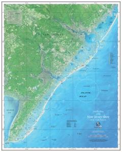 New_Jersey_Shore
$39.00
The New Jersey Shore satellite chart stretches from Long Beach down past the Mullica River to the tip at Cape May at the entrance of the Delaware River.
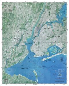 New_York_Harbor
$39.00
This New York Harbor satellite chart depicts New York City and its famous harbors.
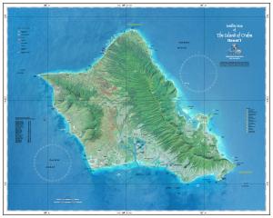 Oahu
Oahu
$39.00
The O'ahu H'awaii satellite chart covers the whole island of O'ahu, Hawai'i, including Honolulu, Pearl Harbor and the North Shore. This chart includes coverage of 18 of the best O'ahu beaches, along with seven of the world's top surfing sites, and 12 of the best island dive sites!
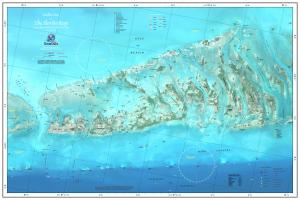
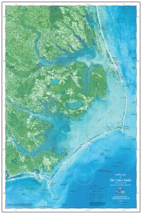 Outer_Banks
$39.00
The Outer Banks satellite chart shows the Outer Banks of North Carolina and covers all the way from the Virginia line to south of Cape Lookout and the Morehead City area. This chart includes popular Cape Hatteras, Kill Devil Hills and Nags Head areas, including the waters of Pamlico and Albemarle Sounds.
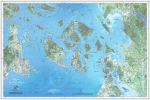 San_Juan_Islands
$39.00
The San Juan Islands satellite chart depicts the San Juan Islands and the surrounding waters and coastal areas. This chart extends west to Victoria, Canada, waters and east to Whidbey Island, Anacortes, and Bellingham along the Washington coast.
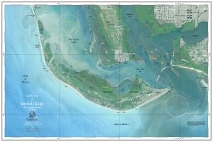 Sanibel_Island
$39.00
The Sanibel Island satellite chart includes Sanibel and Captiva Islands on Florida's Gulf Coast as well as portions of Cape Coral and Fort Myers on the mainland. This chart also includes the waters of Pine Island Sound, San Carlos Bay, Matlacha Pass, and the Caloosahatchee River.
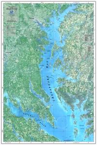 Upper_Chesapeake_Bay
$39.00
The Upper Chesapeake Bay satellite chart shows the north part of the bay including Annapolis, Baltimore, and the Potomac River.
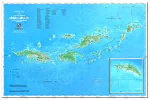 Virgin_Islands
$39.00
The Virgin Islands satellite chart depicts popular vacation and diving destinations in the area including Tortolla, St. John, Anegada, Virgin Gorda, and St. Thomas. This chart also includes part of the Caribbean Sea and several smaller Virgin Islands.


©2025 Nautical Charts Online, All Rights Reserved.