

NGA
- North America
- Central, South America
- Western Africa, Mediterranean, Black Sea
- Eastern Africa, Southern Asia
- Australia, New Zealand, Indonesia, Papua New Guinea
- South Pacific Islands
- Eastern Asia, South Eastern Russia, Philippines
- Other Regions
Canadian
Caribbean and Mediterranean
Norwegian
SHOM
SEMAR
U.S.
Search by chart title, key word or chart number:
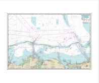
NOAA Nautical Chart 12216OG
Cape Henlopen to Indian River Inlet;Breakwater Harbor

Scale: 40000
Actual Chart Size: 29.5" x 37.6"
Paper Size: 36.0" x 40.0"
Edition #: N/A
Edition Date: 1969-12-31
NTM Notice/Date: N/A None
NTM: https://msi.nga.mil
LNM Notice/Date: N/A 2025-07-10
LNM: http://ocsdata.ncd.noaa.gov/nm
NTM = NGA Notice to Mariners
LNM = Local Notice to Mariners
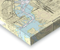
The chart you are viewing is a NOAA chart by OceanGrafix. Printed “on-demand,” it contains all of the latest NOAA updates as of the time of printing. This chart is available for purchase online.
NOTE: ENC data is not entirely compatible with the traditional NOAA chart area scales — and may be unreadable in areas where the incompatibility of scales is represented. Please review the chart carefully. To create your own custom chart, click here
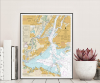
Turn Your Chart Into Art!
We now have five options for chart artwork that are perfect for home or office. Click on one of the options below to get started. We offer a variety of sizes and pricing.


©2025 Nautical Charts Online, All Rights Reserved.